SomeoneElse's Comments
| Changeset | When | Comment |
|---|---|---|
| 180152830 | Also ts2526a |
|
| 179854860 | None of that changes the fact that replacing "Fix member role." with something that described what you did would be helpful. |
|
| 157829963 | What about the northbound signage? |
|
| 179854860 | It'd be ever so helpful if the changeset comment was "Fix member role of (way number name or description) in (relation number name or description". |
|
| 178831301 | Two points:
|
|
| 157829963 | Could you perhaps explain a bit more about the change to https://map.atownsend.org.uk/maps/osm-deep-history/#/way/1305133832 here? "cycle access" doesn't really explain it.
|
|
| 179257638 | Regarding the English name, the airport's own website https://sofia-airport.eu/en/about-us/history/ suggests that the English name is "Sofia Airport". Maybe the website was mostly written before the rename, but you'd think that it would get a mention at https://sofia-airport.eu/en/about-us/history/ .
|
|
| 178995107 | Reverted in changeset/179769897 . If anyone wants to make a map with this in they can use Overpass and date the query to yesterday. |
|
| 179307071 | The Ring of Gullion way had a bit of a gap in it so I filled it in in changeset/179663186
|
|
| 178885367 | Thanks for reverting |
|
| 179502209 | The car park building is visible under construction from Esri and Mapbox imagery, but was actually completed a couple of years ago. The car park extends west out of the building. It is unclear how the parking aisle crosses Steeton Brook; my guess is that that is completely covered now (I didn't look). I saw no indication of any charging suggesting it is free. https://www.yorkshire.com/sutton-in-craven/parking/steeton-silsden also suggests free but council map has a misnamed pay car park located here. Previous OSM status was pay. |
|
| 178998875 | Hello and welcome to OpenStreetMap!
|
|
| 178995107 | Hello,
|
|
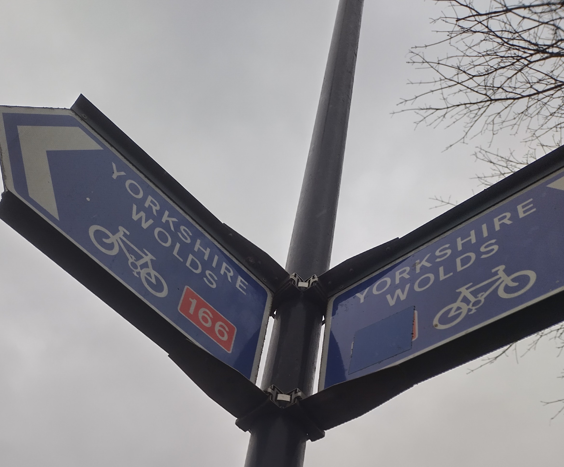
| 178047585 | Ha - well, the current state can be seen at https://map.atownsend.org.uk/tmp/2954c6ef-1c9b-4322-97b0-9da37777c139~1.jpg . One of the 166 references has been stickered over, one hasn't (or perhaps the sticker fell off or was removed). |
|
| 178643492 | Siempre que haya fronteras internacionales en cuestión, definitivamente vale la pena discutirlo en el foro https://community.openstreetmap.org/ en lugar de solo usar discusiones de conjuntos de cambios; de esa manera, más personas estarán al tanto. |
|
| 178643492 | Whenever international boundaries are in question, it's definitely worth discussing in the forum https://community.openstreetmap.org/ rather than just using changeset discussions - that way more people will be aware of it. |
|
| 178839092 | I guess it was important when it was a PIRATA buoy, but what is it important for now (assuming it's not at the bottom of the Atlantic, which alas is likely) |
|
| 178839092 | Hello,
|
|
| 174322735 | Hello,
|
|
| 178466188 | Thanks for filling in this gap. I'm assuming that the other two cycle routes also follow this path, which gives as relation/1318928#map=16/51.54373/-2.63821 , relation/9540148#map=17/51.544247/-2.640468 and relation/5479822#map=17/51.544340/-2.639309 . Does that look OK? |